Routes
King Coal Highway Project Overview
The King Coal Highway—a new four-lane highway with partially controlled access between Williamson and Bluefield—has been designated as "a high priority segment of a high priority corridor in the National Highway System." It ultimately will cover approximately 90 miles of mountainous southern West Virginia, opening the region up to faster, safer transportation.
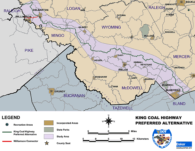
The West Virginia Division of Highways (WVDOH) plans to build the highway from a point near Williamson (at the intersection of WV 65 and US 119) to Interstate 77 at its US 52 interchange in the Bluefield area. After evaluating six alternative routes and considering public feedback, WVDOH selected a Preferred Alternative. Engineers estimate the new highway will cut travel time almost in half compared to the existing US 52.
2.1.1 Preferred Alternative (PA)
The Preferred Alternative is approximately 90 miles (151 kilometers) in length. The route minimizes impact on natural, physical, and social environments while avoiding archaeological resources and business/residential displacements.
Route Description:
- Mingo County: Begins at the intersection of WV 65 and US 119 north of Williamson. It proceeds south and east, crossing Buffalo Mountain and US 52, passing south of Delbarton.
- Ridge Alignment: The PA crosses Mingo County Route 9 and follows the ridge top easterly for approximately 25 miles, passing south of Coon Knob, Hampden, and Sharon Heights.
- Coal Seam Revision: From Twisted Gun Gap to the McDowell county line, the original route encountered areas with burning coal seams. WVDOH revised the PA to the north to avoid these fires, bridging over Mingo County Route 13 and proceeding southeasterly along Skillet Creek Valley.
- Wyoming & McDowell Counties: The route follows Indian Ridge (the Wyoming/McDowell county line) eastward to Crumpler. It passes over Flat Top Mountain, parallels Pinnacle Creek, and crosses the Bluestone River.
- Mercer County: The PA parallels Sandlick Creek, traverses Micajah Ridge, and crosses WV 20. It continues over Hurricane Ridge and Stony Ridge, crossing US 19 and US 460 before terminating at the US 52/I-77 Interchange.
2.1.2 Preferred Alternative – Williamson Connector
The PA includes a proposed 4-lane limited access connector road to facilitate efficient access between Williamson and the main highway. This connector is approximately 4.9 miles (8 kilometers) in length.
Connector Path:
- Begins at Goodman along US 52.
- Proceeds easterly, paralleling Sugartree Creek to the summit adjacent to the Mingo County Airport.
- Passes through the gap north of Sycamore Creek and crosses US 52.
- Proceeds easterly towards Delbarton to intersect with the main King Coal Highway Preferred Alternative.