District 1 Work Zones
Image
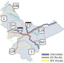
The West Virginia Division of Highways (WVDOH) District 1 manages infrastructure across Boone, Clay, Kanawha, Mason, and Putnam counties. Below is an overview of active road work projects within the district. Only work activities that are expected to affect traffic are listed.
Daily Road Report
For the most up-to-date and comprehensive list of lane closures, traffic delays, and active work zones, please review the official daily report:
Download the District 1 Daily Road Report (PDF)
Work Zones by Category
Information is categorized by the type of roadway and specific county locations. On this page, you will find updates for:
- Interstate Work Zones (e.g., I-64, I-77, I-79)
- US Route Work Zones (e.g., US 35, US 60, US 119)
- County Work Zones:
- Boone County
- Clay County
- Kanawha County
- Mason County
- Putnam County