Districts
Image
District Information
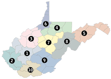
Choose a district for detailed information about highway projects, work zones and local office contacts.
| District | Counties |
|---|---|
| District 1 | Boone, Clay, Kanawha, Mason and Putnam counties |
| District 2 | Cabell, Lincoln, Logan, Mingo and Wayne counties |
| District 3 | Calhoun, Jackson, Pleasants, Ritchie, Roane, Wirt and Wood counties |
| District 4 | Doddridge, Harrison, Marion, Monongalia, Preston and Taylor counties |
| District 5 | Berkeley, Grant, Hampshire, Hardy, Jefferson, Mineral and Morgan counties |
| District 6 | Brooke, Hancock, Marshall, Ohio, Tyler and Wetzel counties |
| District 7 | Barbour, Braxton, Gilmer, Lewis, Upshur and Webster counties |
| District 8 | Pendleton, Pocahontas, Randolph and Tucker counties |
| District 9 | Fayette, Greenbrier, Monroe, Nicholas and Summers counties |
| District 10 | McDowell, Mercer, Raleigh and Wyoming counties |