The West Virginia Department of Transportation (WVDOT) supports free data exchange with other organizations and the general public.
For additional WVDOT GIS data, please visit the WVDOT Open Data Portal at https://data-wvdot.opendata.arcgis.com/
The GIS data is published in ESRI shapefile format and compressed as ZIP files. Some of the data is also published as
web services. The spatial reference for the data is Universal Transverse Mercator (UTM), Zone 17, and North American Datum (NAD) 83.
Transportation GIS Data
LRS Road Network Data
The WVDOT
linear referencing system (LRS) contains multiple linear referencing methods (LRMs) by which events (assets or activities) are recorded against a location in the agency’s highway network.
The LRS road network data here is developed based on the Countywide Milepoint LRM. Per the LRM, Interstates are set up as continuous routes across county boundaries and their mile points are not reset at county boundaries. However, such a route has a unique Route ID in each county that it crosses; and for all the other routes, belonging to various other sign systems, their Start / End mile points are reset at county boundaries. For more detail on the WVDOT Countywide Milepoint LRM, please refer to the documents below.
The WVDOT has developed 2 web applications related to the LRS network.
Geometry & Measures is a web map app which allows the user to get Route ID and milepoint data from a point on the map and to use known Route ID and milepoint data or Latitude and Longitude coordinates to show a point or sequence of points on a map. The
Route ID Builder helps the user to generate a valid Route ID by choosing components based on the LRS network. For example, when a user chooses a county, the only Sign Systems shown are those that are valid for that specific county. Choosing a Sign System will filter the Route Numbers to only those for that particular county and Sign System. This filtering continues until a valid Route ID is generated.
Please keep in mind:
-
Only dominant route data is published. The general rule for route dominancy is: among all the concurrent routes the route with the lowest sign system code dominates. If more than one route shares the same lowest sign system code the one with the smallest route number dominates.
- Measures embedded in routes are derived by linear interpolation based on calibration point data collected by using a Distance Measuring Instrument (DMI) except for ramps whose measures are derived based on geometry length.
-
The LRS network data is published once every six months. The current LRS road network data is as of December 2023.
Major Roads
Roads by WVDOT Division of Highways District
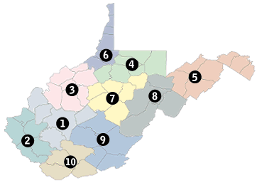
WVDOT Division of Highways District Map

For questions or comments, please contact us at DOTSupport@wv.gov.